
The Andorville™ Coordinates software converts coordinates between different reference systems.
The software uses the EPSG Geodetic Parameter Dataset: EPSG Home Page.
Longitude and latitude coordinates are used to locate points on the surface of a globe.
The values of the longitude and latitude for a particular location depends on the datum used to define the coordinates.
A geographic datum consisits of an ellipsoid and a prime meridian.
The ellipsoid is specified by a semi-major axis length and a semi-minor axis length and how the ellipsoid is fitted to the earth.
The ellipsoid inverse flattening value is commonly specified instead of the semi-minor axis length.
The prime meridian is the zero longitude reference, usually passing through Greenwich.
To display locations on a flat sheet of paper (a map) instead of a globe, projections are used.
A projection converts the longitude and latitude coordinates used to define a location on a globe to easting and northing coordinates used to define a location on a flat surface.
Latitude, longitude and ellipsoidal height coordinate values specify a point in 3D space.
A 3D space location can also be defined using cartesian coordinates, where the X, Y and Z axes are aligned with the ellipsoid axes and prime meridian.
The Coordinates software converts locations between projected, geographic and cartesian coordinates within a coordinate reference system.
The software can also convert locations to the coordinates corresponding to other reference systems.
The coordinate conversion form is shown below. This form shows the longitude and latitude coordinates entered for a collection of wells drilled on a gas-condensate field, offshore Western Australia.
The coordinates are entered as decimal degrees in the coordinate reference system GDA94/MGA zone 51.
The corresponding projected easting and northing values are calculated.
The coordinate values have also been transformed to the current coordinate reference system GDA2020/MGA zone 51.
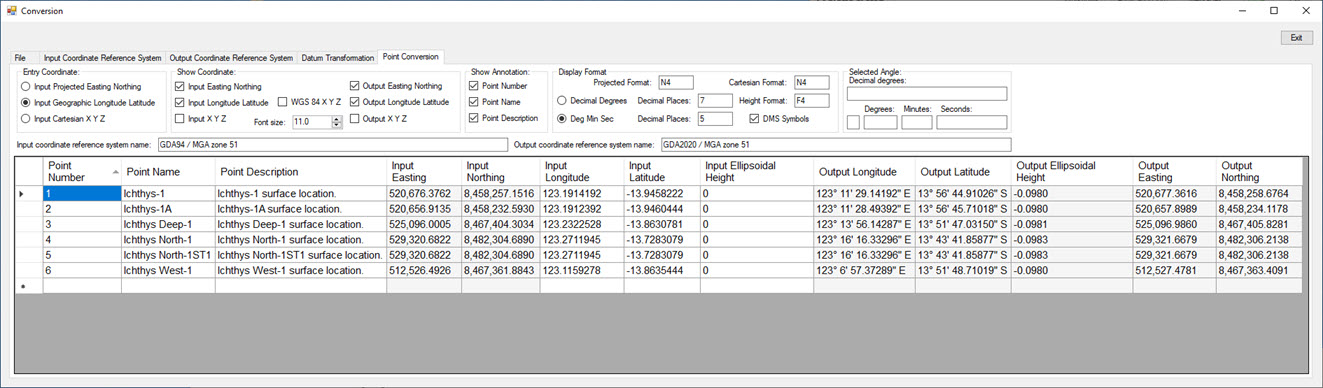
The Coordinate Conversion Form.
The source code for the software can be downloaded from this GitHub page: ADVL_Coordinates_2
If you have any questions or comments, contact me at
The software currently supports universal transverse mercator coordinate projections and Helmert 7 parameter datum transformations.
Geodetic parameters are read directly from the Microsoft Access version of the EPSG Dataset.
The software has been tested using the database version: EPSG-v10_076-Access.mdb .
All of the tables in the database can be viewed using the software.
Within a coordinate reference system, a location can be defined using the following coordinate systems:
Projected: Easting and Northing coordinates (for projected coordinate reference systems)
Geographic: Longitude, Latitude and Ellipsoidal Height coordinates
Cartesian: X, Y and Z coordinates.
Within a reference system, locations can be converted between projected, geographic and cartesian coordinates.
Coordinates can be converted from one reference system to another using a datum transformation operation.
Different coordinate reference systems use different datums. A geodetic datum consist of an ellipsoid and a prime meridian.
Changing the ellipsoid and prime meridian parameters will change the latitide and longitude values of a location defined using that datum.
The corresponding projected (easting and northing) and cartesian (X, Y and Z) coordinates will also change.
The Helmert 7 parameter transformation is used to convert X, Y, Z locations between reference systems.
Geographic coordinates can be entered in any format such as decimal degrees or degrees, minutes and seconds.
Point conversion settings and the converted locations of a set of points can be saved in a file.